IMPORTANT NOTES
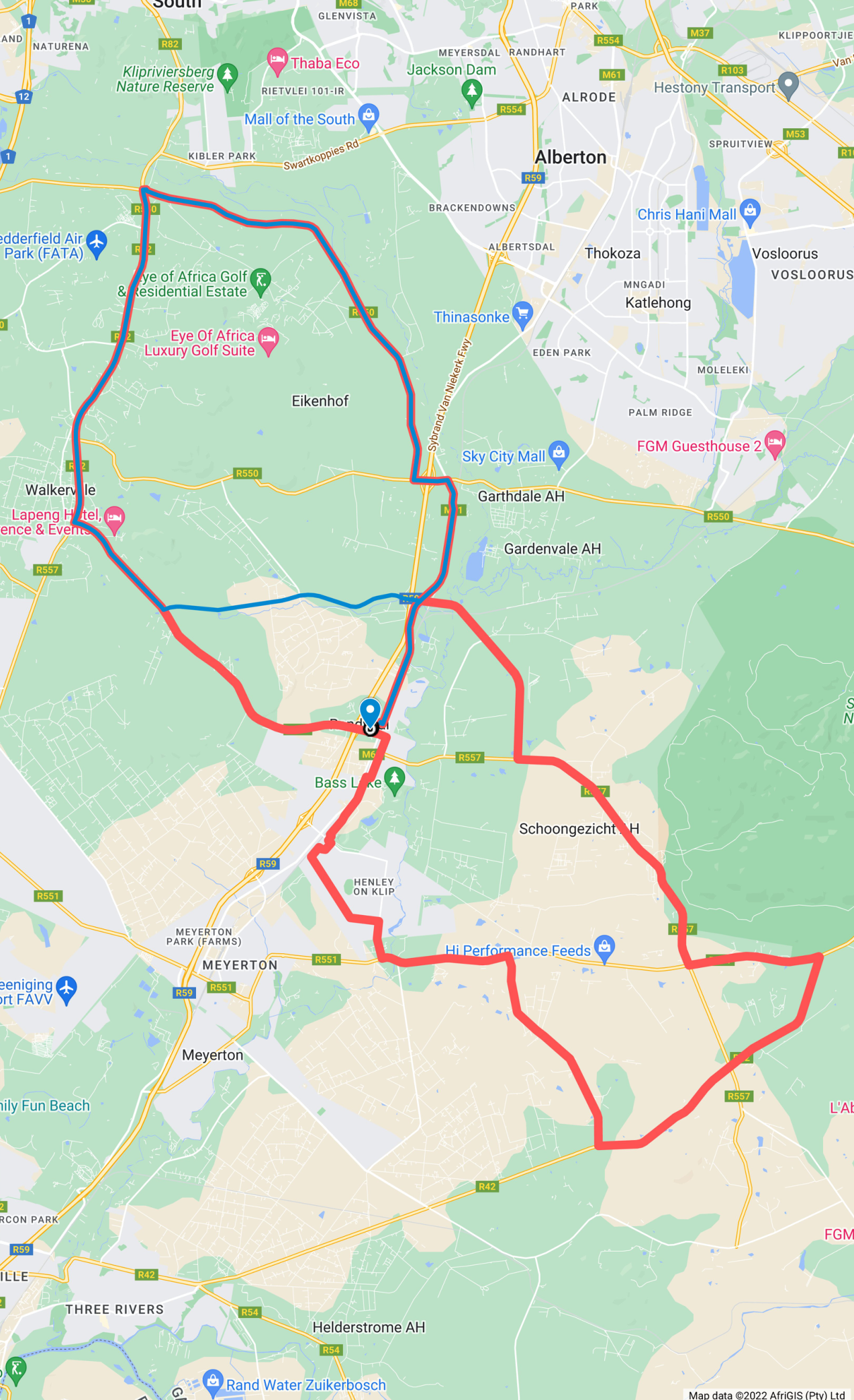
110 km RACE
PLEASE NOTE: THE ONLY ACCESS TO THE VENUE IS VIA THE R59.
THERE IS ROAD CLOSURE FROM 04:00 – 15:00 FROM JOAN ROAD UP TO AFFODIL STREET
• The first 4,1 km and the final 4,1 km of the event is on the same route.
• At 8,5 km mark PAY ATTENTION at Nampak intersection – bumpy roads / pedestrians. Turn left and then cross over highway (R59) and turn right at
9,6 km.
• Cycle along Kliprivier Road for another 6,5 km until the R82 intersection.
• First water point at 25 km mark close to Panda Sportswear.
• Long uphill drag (10 km) to Walkerville. First tester for legs! (CAUTION! 13 intersections on this road, marshals at all intersections. Double carriageway!
• Sharp turn left into Randvaal Road at 36 km.
• Rumble Strips at 35km.
• Pass Lapeng Centre on left.
• Rumble Strips at 39km.
• Continue on Randvaal Road, (DO NOT TURN LEFT INTO JOAN RD) over the R59 and railway line bridge, Start venue on your left hand side.
• Turn right into Daleside into Kroonarend road
• Turn right into Karee Road, the church is on your left hand side.
• Turn left at the next intersection into Bokmakierie Road. This is a 3km flat section with the railway line on your right hand side, past the crushers on your left side. At the entrance to the crushers you will encounter a short piece of cobbles.
• Rumble Strips at 59km.
• You will now encounter an S bend and then turn left to cross Henley Drive.
• Make a right turn into Blougras and left again into Kruisgras.
• Cross over into The Avenue. The next 6km is through the outskirts of the town Henley-on-Klip. It is fairly flat but with many intersections and sharp S bends where you need to concentrate.
• 1st intersection: The Avenue, St Davids and Shillings Ford street (church on your right)
• 2nd intersection: The Avenue, St Martins and Wargrave Road, cross over (left). Big dip in the road.
• You will go past the Oprah Winfery School (back of school). The second Water Point is situated here in The Avenue.
• Turn right into Ewelme Road.
• You will cross over two speed humps and the retirement village (left hand side).
• When coming out of Henley-On-Klip, turn left onto Verwoerd road. You will cross the Klipriver.
• Turn right onto the Bloemendal Road / Aerials route and continue for 7,2km.
• Turn left onto the R42 for 9,7km. Be cautious, this is a very busy road. Go past the first road that turn to your left.
• Turn left onto Verwoerd Road, continue for 4,3km.
• Turn right at the intersection into Karee Road. The nature reserve is on your right hand side. The THIRD WATER POINT is situated opposite the entrance of the nature reserve. Big Baboons on this stretch.
• Turn right in the slipway into Joan Road. Continue for 7km.
• Left turn into Springbok Road (M61) in southerly direction back home towards the Circus.
• Road closure from this point onwards, i.e. Joan road to Finish.
• FINISH at 110 km.
ROUTE MAP
CLICK HERE TO DOWNLOAD AND PRINT
RIDE AND ARRIVE SAFE